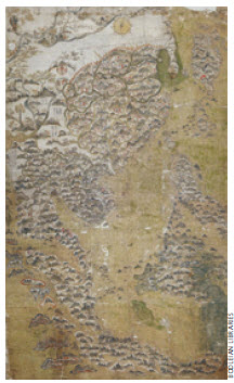
The Selden watercolour map dates from the late Ming period and shows China, Korea, Japan, the Philippines, Indonesia, Southeast Asia and part of India.
The Selden watercolour map dates from the late Ming period and shows China, Korea, Japan, the Philippines, Indonesia, Southeast Asia and part of India.
« Previous Image | Full-Size Image |
Main Gallery Page
Other Images in this Gallery
-

-
Hedwig Eva Maria Kiesler, also known as Hedy Lamarr, first became famous in Prague rather than in Budapest or her native Vienna.Hedwig Eva Maria Kiesler, also known as Hedy Lamarr, first became famous in Prague rather than in Budapest or her native Vienna.
-

-
-
The Selden watercolour map dates from the late Ming period and shows China, Korea, Japan, the Philippines, Indonesia, Southeast Asia and part of India.